Monday, November 26, 2012


Sunday, April 1, 2012
April Fool's Snowfall
Last day of March was 80F, which means Spring is officially here, right? Wrong. Mother Nature brought snow on April 1st.
I hiked the "zigzag trail" above Centerville to continue my training for summer hiking and to see what the Mahogany trees looked like in snow. It was worth the effort.

Looking south over Bountiful, you can clearly see the snow line, and also the trees and some lawns turning green, thinking it was spring.


The Mahogany grove on "The Saddle", looking E-SE

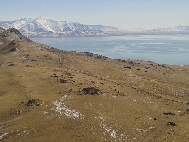
From the summit, looking west past Mahogany and Scrub Oak to Antelope Island


I hiked the "zigzag trail" above Centerville to continue my training for summer hiking and to see what the Mahogany trees looked like in snow. It was worth the effort.

Looking south over Bountiful, you can clearly see the snow line, and also the trees and some lawns turning green, thinking it was spring.

Looking west past the ridge to Antelope Island.

The Mahogany grove on "The Saddle", looking E-SE

From the summit, looking west past Mahogany and Scrub Oak to Antelope Island

The sun finally broke out over Antelope Island while snow squalls stayed over the Wasatch

From the top, looking north you can easily see the main runway at Hill AFB. Notice how the rubber marks (from tires making contact at landing) is concentrated on the north end of the runway - planes rarely land at HAFB coming from the south.

I waited & waited for the sun to come out & give some stunning light to the landscape; it never did, but there were a few decent shots anyway.
Saturday, March 31, 2012
Mount Wire
Last day of March, a beautiful day, nice & warm, upper 70s.
I planned on going to a U of U spring football practice, but driving up to the stadium it became apparent I messed up the schedule & there was no practice. No problem, I decided to hike Mount Wire, a 2000 vertical foot workout just east of Research Park, part of my quest to get ready for hiking season. Didn't bring the camera, so these are from the phone-camera.
Looking west from the top, the U of U, Rice Eccles Stadium and downtown SLC are all getting drenched in sunshine.

Windy as hell that day - really, really strong winds from the south portending a nice little April Fool's surprise snow storm the next morning.

Sunday, March 4, 2012
"The Sentinal" - Antelope Island
On the south end of Antelope Island there is a very level ridge that stands out from a distance. It was part of the old Lake Bonneville shoreline, a distinctly level part of the north-south spine of ridges that make up the island. In the middle of this 1 or 2 mile level-line is a spike that emerges (actually probably 2/3 of the way north of the spine) called "The Sentinenl".

On a sunny March Sunday I decided it was time to see what the view from this perch looked like, so I drove out to Antelope and parked some miles north on a trailhead mostly intended for horse riders. Heading south and gradually climbing the east bench of Antelope toward The Sentinel it wasn't long before I encountered Buffalo (Bison) and a couple of Antelope. The Bison are a lot like cattle. They're curious to see what's coming near them, but they'll scatter when you get close.
I also learned the hard way that winter had made my camera batteries seem more charged than they really were, so these pictures were all taken with a cheap phone camera.
Buffalo urgently moving away from guy with phone camera:

Looking east at Frary Peak from the east bench:

A couple of groups of Buffalo from higher on the bench:

Nearing the top of The Sentinal, looking west toward Stansbury Island

Looking south from on top

Hiking back to the car, through lots of yellow grass, with the Wasatch in the background to the east

On a sunny March Sunday I decided it was time to see what the view from this perch looked like, so I drove out to Antelope and parked some miles north on a trailhead mostly intended for horse riders. Heading south and gradually climbing the east bench of Antelope toward The Sentinel it wasn't long before I encountered Buffalo (Bison) and a couple of Antelope. The Bison are a lot like cattle. They're curious to see what's coming near them, but they'll scatter when you get close.
I also learned the hard way that winter had made my camera batteries seem more charged than they really were, so these pictures were all taken with a cheap phone camera.
Buffalo urgently moving away from guy with phone camera:

Looking east at Frary Peak from the east bench:

A couple of groups of Buffalo from higher on the bench:

Nearing the top of The Sentinal, looking west toward Stansbury Island

Looking south from on top
Hiking back to the car, through lots of yellow grass, with the Wasatch in the background to the east

Sunday, October 2, 2011
SLC foothills
Salt Lake City is on the eastern edge of the Great Basin, with the Wasatch Mountains on the eastern edge of SLC being considered part of the Rocky Mountains, and the Salt Lake Valley as a classic basin in the Basin & Range topography.
In the northeast corner of the Salt Lake Valley is the University of Utah, with foothills of the Wasatch just east of the campus.
I hiked up a short canyon and then circled back to the west, climbing the foothill where the "U" on the hill is located.
Looking south over the foothills toward Lone Peak, a 11,000 foot peak SE of SLC:


From on top of the foothill, looking west over the northern foothills, to the Great Salt Lake and Stansbury Island in the background:


The western flank of Mount Olympus, and Lone Peak. If you look closely, you can see the small glacier on Lone Peak's northeastern exposure:


U of U Health Sciences Center:

In the northeast corner of the Salt Lake Valley is the University of Utah, with foothills of the Wasatch just east of the campus.
I hiked up a short canyon and then circled back to the west, climbing the foothill where the "U" on the hill is located.
Looking south over the foothills toward Lone Peak, a 11,000 foot peak SE of SLC:

The same view, with Mount Olympus in the background:


The Salt Lake aiport control tower, with the Great Salt Lake and Stansbury Island:

Mount Olympus, with Lone Peak in the background:


Draper Ridge, leading up to Lone Peak:

University of Utah Health Sciences Center, Mount Olympus:


Saturday, September 24, 2011
Mount Moriah, eastern Nevada
This is another peak on my bucket list. I hiked Wheeler Peak - which is south of Mt Moriah, also in the Snake Range - waaay back before it became part of Great Basin National Park.
Drove out to Ely, NV after work on Friday to get a good night's rest before talking on Mt Moriah, which proved to be a good idea, because this mountain is a real muthuh. I took the "easy" route, driving north through Spring Valley from Highway 50 east of Ely. After about 15 miles on dirt road, you take right and go eastbound on Forest Service road 469, which ascends rapidly on what amounts to foothill's on Mt. Moriah's western edge. Once you get on top of the foothills, the vistas emerge in all directions. Another 7 miles or so of driving on pretty rocky jeep trails gets you to the Big Canyon trailhead, which is a big headstart to the peak, compared to the eastern canyons, Hampton & Hendry.
Looking south along the western edge of the Snake Range, from Spring Valley:

Climbing up the western foothills of Mt. Moriah, looking west across Spring Valley to the Schell Creek Mountains, with Yelland (Dry) Lake in view:

Once on top of the foothills, looking south to Wheeler Peak in Great Basin National Park:

Big Canyon trailhead. (It looks like the sign could use a little touchup work):

Mount Moriah, from the north. Note the late summer / early fall snow around the peak.

Much like Wheeler Peak, Mt. Moriah had significant erosion from glaciers in the last ice age, and Big Canyon is carved out of the north side of the mountain, with a lot of talus in a upper part of the canyon:

North of the Mt Moriah peak is maybe the most distinctive part of this mountain, "The Table", which is a remarkably flat area of maybe 300 or 400 hundred acres. You could easily have a gigantic game of flag football or soccer, or lacrosse up here, except that it's at about 11,000 feet, which means you get out of breath very, very quickly. Looking north over The Table, with the Deep Creek Mountains in Utah in the distance:

On the eastern flank of Mt Moriah, a Bristlecone Pine, which is one of the oldest species of plant life on the planet. A researcher cut down a Bristlecone Pine on Wheeler Peak in the 60s, only to discover it was over 4400 years old.


The view from the top of Mt Moriah was spectacular! I could make out peaks in every direction that were between 80 and 130 miles away (though faint on the longer distances). Peaks visible were Pilot Peak to the north, Deseret Peak to the NE, Mount Nebo to the E/NE, Notch Peak in the House Range to the east, Indian Peak to the SE, Wheeler Peak to the South (of course) the Egan Range and Schell Creek Range to the SW & West, Spruce Mountain to the NW.
Another view of Wheeler Peak to the south:


Drove out to Ely, NV after work on Friday to get a good night's rest before talking on Mt Moriah, which proved to be a good idea, because this mountain is a real muthuh. I took the "easy" route, driving north through Spring Valley from Highway 50 east of Ely. After about 15 miles on dirt road, you take right and go eastbound on Forest Service road 469, which ascends rapidly on what amounts to foothill's on Mt. Moriah's western edge. Once you get on top of the foothills, the vistas emerge in all directions. Another 7 miles or so of driving on pretty rocky jeep trails gets you to the Big Canyon trailhead, which is a big headstart to the peak, compared to the eastern canyons, Hampton & Hendry.
Looking south along the western edge of the Snake Range, from Spring Valley:


Once on top of the foothills, looking south to Wheeler Peak in Great Basin National Park:

Big Canyon trailhead. (It looks like the sign could use a little touchup work):

Mount Moriah, from the north. Note the late summer / early fall snow around the peak.

Much like Wheeler Peak, Mt. Moriah had significant erosion from glaciers in the last ice age, and Big Canyon is carved out of the north side of the mountain, with a lot of talus in a upper part of the canyon:


On the eastern flank of Mt Moriah, a Bristlecone Pine, which is one of the oldest species of plant life on the planet. A researcher cut down a Bristlecone Pine on Wheeler Peak in the 60s, only to discover it was over 4400 years old.

Got the summit!!

The view from the top of Mt Moriah was spectacular! I could make out peaks in every direction that were between 80 and 130 miles away (though faint on the longer distances). Peaks visible were Pilot Peak to the north, Deseret Peak to the NE, Mount Nebo to the E/NE, Notch Peak in the House Range to the east, Indian Peak to the SE, Wheeler Peak to the South (of course) the Egan Range and Schell Creek Range to the SW & West, Spruce Mountain to the NW.
Another view of Wheeler Peak to the south:

On the way back down, looking north. The northern part of the Snake Range is more arid, looking north toward the Deep Creek Mountains:

Heading back down the western slope, looking at Spring Valley to the west. (Spring Valley is one of the valleys the Las Vegas water authorities are trying to acquire for a pipeline to Sin City. Think Spring Valley already looks pretty dry? Me, too.)

Last few moments of daylight:

Subscribe to:
Posts (Atom)