Took a quick drive up Skyline Drive above Bountiful after work to a overlook east of Centerville. Great weather, easy photos, life is grand.
Southern part of Antelope Island, with Stansbury Island behind that, the Lakeside Mountains, and if you look very close (extremely faint), you can see Pilot Peak, Nevada (which is about 115 miles almost directly west):

Pyramid Peak (aka "Cave Peak"), with the new Kern River pipeline gash right behind it.

Frary Peak on Antelope Island, with what looks to be a B737 on approach to SLC:

Pastel sunset of Antelope Island, with the Hogup Mountains on the other side of the GSL behind:


After sunset, the lights are starting to come on in Bountiful, with Antelope Island on the right, and the northern part of the Oquirrh Mountains on the left side, in the distance:

Layer of clouds, looking into the sunset area, past the lake and toward the Hogup Mountains:

Southern part of Antelope Island, with Stansbury Island behind that, the Lakeside Mountains, and if you look very close (extremely faint), you can see Pilot Peak, Nevada (which is about 115 miles almost directly west):

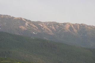
Black Mountain, above Bountiful:

Pyramid Peak (aka "Cave Peak"), with the new Kern River pipeline gash right behind it.

Frary Peak on Antelope Island, with what looks to be a B737 on approach to SLC:

Pastel sunset of Antelope Island, with the Hogup Mountains on the other side of the GSL behind:

This time of year the sun sets pretty far north - from this spot it goes down in the northern part of the Great Salt Lake:


Layer of clouds, looking into the sunset area, past the lake and toward the Hogup Mountains:


